Showing posts with label IMAGE INTERPRETATION. Show all posts

Monday, 14 April 2014

What is Image Classification?

What is Image Classification?

Remote sensing is the science and the art of obtaining information about an object, area, or phenomenon through the analysis of data acquired by a device that is not contact with the object, area or phenomenon under investigation.(Lillesand and Kiefer, 1994). The images taken are in the form of pixel and the process of changing it into digital images that make sense is known as image classification.It is based on technique that provides information through images. For eg.Land cover futher categorised into- forest,water,agriculture etc.

The two basic classifications are:

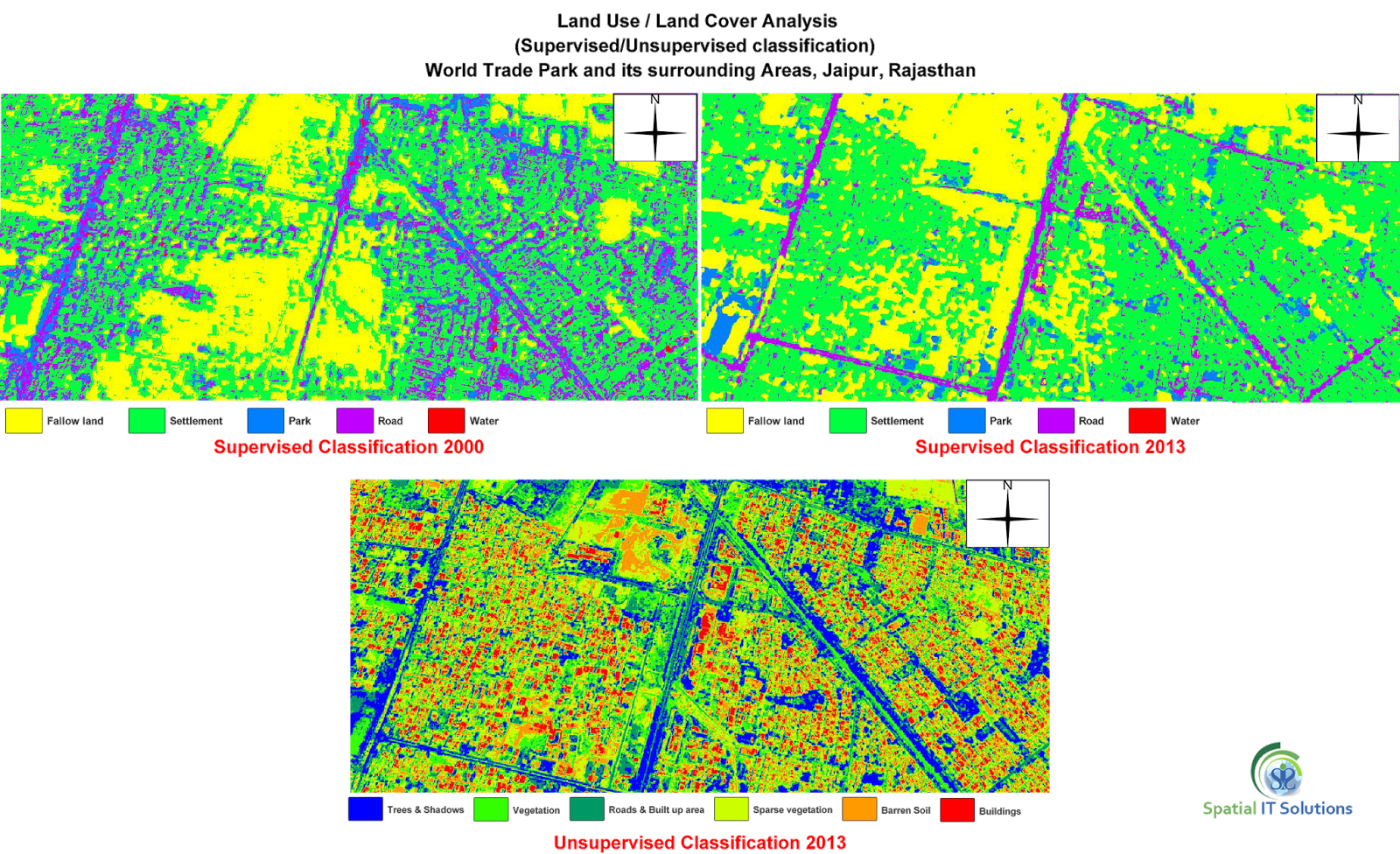
  1. Supervised
  2. Unsupervised

1.  Supervised- This classification requires "training sites" where a person is aware about the ground so that a polygon can be digitized of that area.The image processing software system is then used to develop a statistical characterization of the reflectance for each information class. This stage is often called "signature analysis" and may involve developing a characterization as simple as the mean or the rage of reflectance on each bands, or as complex as detailed analyses of the mean, variances and covariance over all bands.(Eastman, 1995)

Supervised classification is further classified into:
  • Parallelpiped
  • Minimum distance to mean
  • Maximum likelihood

2.  Unsupervised- Unsupervised classification is a method which examines a large number of unknown pixels and divides into a number of classed based on natural groupings present in the image values. unlike supervised classification, unsupervised classification does not require analyst-specified training data. The basic premise is that values within a given cover type should be close together in the measurement space (i.e. have similar gray levels), whereas data in different classes should be comparatively well separated (i.e. have very different gray levels) (PCI, 1997; Lillesand and Kiefer, 1994; Eastman, 1995 )

Unsupervised is further classified into technique:

  • K-Means classification
  • SODATA classification
  • Expectation Maximization (EM)classification

Geospatial Consulting Services in India


Wednesday, 2 April 2014

WHAT IS IMAGE INTERPRETATION?

Image interpretation

Image interpretation is related with the identification of  remote sensed objects or images and knowing about their significance. To see the useful result of image interpretation the primary tasks are:
  • Detection
  • Identification
  • Measurement
  • Problem solving
Image interpretation

Detection- It is a primary task to detect or identify an object or feature.

Identification- When a particular target is identified or recognized, for example types of soil, vegetation, forest, rock etc.

Measurement- Measurement is related to the area, length, volume etc. of the targeted objects like  forest, rock, water bodies etc.

Problem solving-Image interpretation also involves problem solving that means when an object or the feature is identified an analyst may also be asked to give the complex significances of an image which is sometimes not depicted and so the statement is given as a probability of correction.

The Attributes on which Interpretation is based are:
 
  1. Location
  2. Size
  3. Shape
  4. Shadow
  5. Tone/colour
  6. Texture
  7. Pattern
  8. Height and depth
  9. Site/situation
  10. Association

1.Location- It is related with the position of the object that is global positioning of an object or feature.

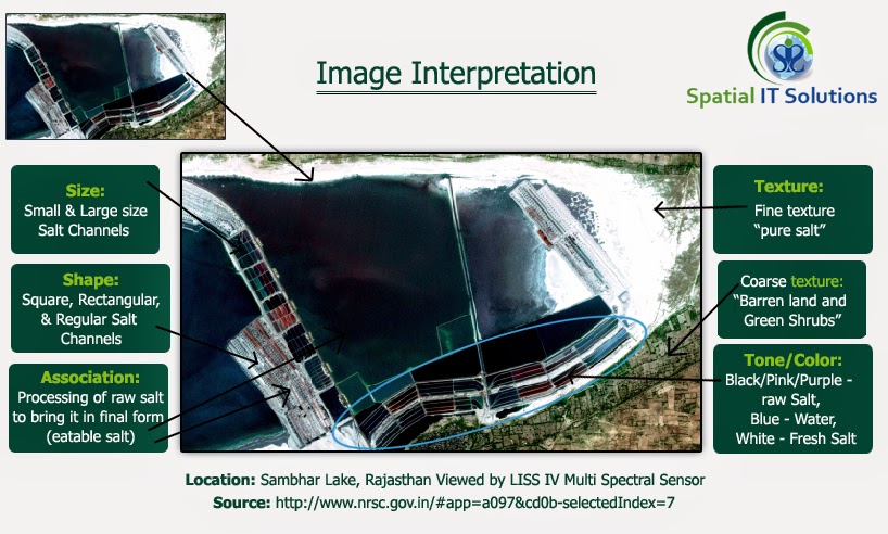
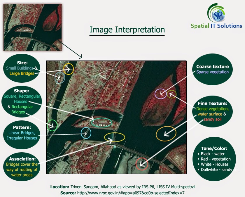
2.Size- Size is one of the most important things to know as it tells about the length, breath and perimeter about the feature.It is important to know about the scale. Example sports fields.

3.Shape- The Shape also helps in image interpretation.There are numerous objects on the earth's surface with different shapes and features that helps to interpret.

4.Shadow- Shadow helps in identification of the objects like mountain, building, trees, etc. depending upon the low angle of the sun.

5.Tone/color- Tone refers to the shades of black, white and grey and color refers to the different combination of hue that is blue, green, red which is reflected from vegetation, water, soil etc. An interpreter can interpret through the specific reflected wavelength.

6.Texture- If the tone of different objects is uniform, then the texture helps to interpret the images through smoothness or coarseness.

7.Pattern- Pattern is related with the arrangement of objects, whether natural or man made on the land like settlement pattern, drainage pattern etc. For example some of the patterns are rectangular, triangular, linear, radial etc.

8.Height/depth- It is related with the elevation and is most helpful in detecting the images as it cast shadow depending upon the height and angle of the sun. Buildings and electric poles are the good examples as they are raised from the the ground.

9.Site/Situation/Association - Site here refers to the surroundings or the environment wheather natural or man made, for example regions like slope,hill, plateau, forest, soil etc. Whereas the situation refers to how these are arranged or situated in which manner. For example industries like steel plant industry. Assocition means the common features that is commonly associated with each other. Site, Situation and association mostly work together they are rarely independent. Example a large shopping mall is associated with number of buildings, parking lots, roads etc.