Showing posts with label Geospatial Training Services. Show all posts
Showing posts with label Geospatial Training Services. Show all posts
Tuesday, 29 April 2014
Monday, 14 April 2014
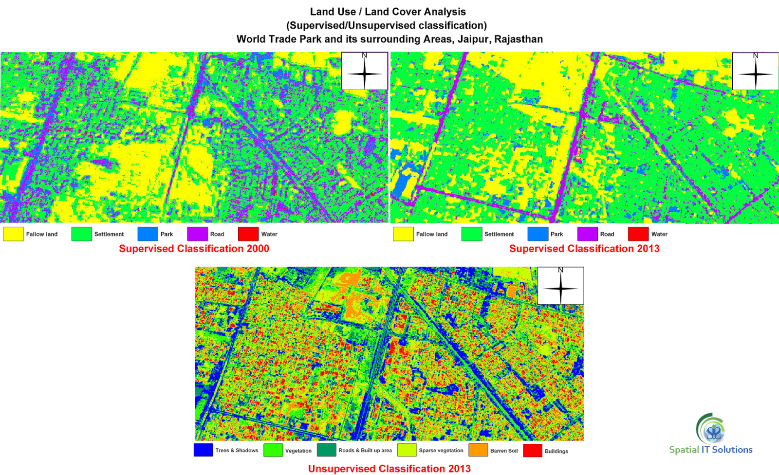
What is Image Classification?
 |
| What is Image Classification? |
Remote sensing is the science and the art of obtaining information about an object, area, or phenomenon through the analysis of data acquired by a device that is not contact with the object, area or phenomenon under investigation.(Lillesand and Kiefer, 1994). The images taken are in the form of pixel and the process of changing it into digital images that make sense is known as image classification.It is based on technique that provides information through images. For eg.Land cover futher categorised into- forest,water,agriculture etc.
The two basic classifications are:
- Supervised
- Unsupervised
1. Supervised- This classification requires "training sites" where a person is aware about the ground so that a polygon can be digitized of that area.The image processing software system is then used to develop a statistical characterization of the reflectance for each information class. This stage is often called "signature analysis" and may involve developing a characterization as simple as the mean or the rage of reflectance on each bands, or as complex as detailed analyses of the mean, variances and covariance over all bands.(Eastman, 1995)
Supervised classification is further classified into:
- Parallelpiped
- Minimum distance to mean
- Maximum likelihood
2. Unsupervised- Unsupervised classification is a method which examines a large number of unknown pixels and divides into a number of classed based on natural groupings present in the image values. unlike supervised classification, unsupervised classification does not require analyst-specified training data. The basic premise is that values within a given cover type should be close together in the measurement space (i.e. have similar gray levels), whereas data in different classes should be comparatively well separated (i.e. have very different gray levels) (PCI, 1997; Lillesand and Kiefer, 1994; Eastman, 1995 )
Unsupervised is further classified into technique:
- K-Means classification
- SODATA classification
- Expectation Maximization (EM)classification
Geospatial Consulting Services in India
Thursday, 10 April 2014
APPLICATIONS OF REMOTE SENSING
 |
| Application of Remote Sensing |
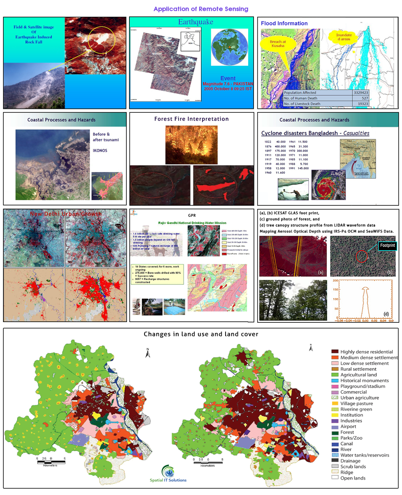
Remote sensing is a technique to know about the various geographical features of the earth that is in the remote areas. We can know about the object or features without coming in any physical or direct contact with them and this is just because the planet earth and its environment are being observed by the number of satellites that are orbiting around the earth.
There are a large number of things being observed and covered by the satellite and all are of several fields. There are variety of remote sensing applications like climatology, oceanography, agriculture, etc. India has its own satellites Bhaskara, Rohini, Insat, IRS etc.
Some remote sensing applications are:
- Land cover and land use
- Agriculture
- Forestry
- Geology
- Geomorphology
- Hydrology
- Mapping
- Ocean and coastal monitoring
- Monitoring of Atmospheric Constituents
- Land use and land cover- Both land cover and use are different as land use is related to the various activities of human in which way they use the land for ex.-industrial, residencial, recreational etc. Whereas land cover is related to the physical state of the land ex.-forest,grassland,minerals etc.
- Agriculture-Remote sensing application in agriculture helps in identification of crops, its yield, management, condition farming etc.
- Forestry-It helps in monitoring the type of forest, its coverage, exploitation and many other ways application is helpful.
- Geology-The application in geology is helpful in knowing about the earth's crust. It provides knowledge about the landform, structure, composition by physical, chemical and biological changes on and within the surface. We come to know about deposition, bedrock, minerals, soil etc.
- Geomorphology- In geomorphology the remote sensing application tells about the landform and the process that are being used i.e. endogenetic and exogenetic processes. That includes volcanic, plate tectonic, weathering, erosion etc.
- Hydrology-This is the application that gives information about every process that is related with water for ex. water quality,soil moisture, snow,flood,lake etc.
- Mapping-Mapping is related to each and every activity that is being covered by the satellite. The remotely sensed data that are captures are shown on the maps. Through mapping we get to know about the land cover, settlements, types of crop, soil, etc.
- Oceans and coastal monitoring-Ocean application of remote sensing helps identification of the ocean and each and every activity related to oceans like shipping, oil spill, storm, currents etc.
- Monitoring of atmospheric constituent-Remote sensing application of atmospheric constituent includes water vapour,methane,carbon-di-oxide,ozone,etc.
There are endless application of remote sensing that can be used in various fields and process of land, ocean and atmosphere. There are so many applications that proved effective, whereas some are not that effective and so it is being improved by the technology.
More Info: Geospatial Consulting Services
Wednesday, 9 April 2014
Saturday, 5 April 2014
Tuesday, 11 March 2014
HOW TO USE POINT, LINE AND POLYGON IN A MAP?
The word GIS stands for Geographical Information System. It is a technology that gives us information about various things and places on the earth's surface or we can even define it as a technology that is used to view and analyze data from a geographic/ geospatial perspective. Similarly, there is a software known as QGIS previously known as Quantum GIS which helps in making maps or you can say that it plays a major role in the map projection.
The QGIS is very useful for the Thematic maps. The basic files used in creating maps are:
- Raster
- Vector
In raster files, images contain in the form of pixels, or cells, whereas vector files Points, Lines and Polygons for making images.
 |
| HOW TO USE POINT, LINE AND POLYGON IN A MAP? |
- Point: It is used to specify a particular thing or position on the earth's surface, specially used in GPS for the positioning. It is also known as a coordinates that shows the exact location which is very helpful in making maps. The smallest geographical features are well specified by the points where lines and polygons cannot be used. The point is a mark or dot used in the starting and at the end.
- Line: It is used to show the narrow features on the map or you can say the length of the features like road, railway, streams, etc. Lines show the shape and direction which is in more detailed manner that it easier for the users.
- Polygon: It is used to show a particular area or geographical features like a state, particular district, wetland, agriculture, forest, etc. Polygons are the series of nodes that are joined together. The starting and the ending point is the same that means when we draw a polygon we have to end at the same node from where we started.
Monday, 18 November 2013
What is GIS ?
The
basic question that might arise in the mind of a newcomer in the field
of GIS would be what is GIS and its basic components. Here in this
section we will discuss in detail the definition and the components of
GIS.
A
Geographical Information System (GIS) integrates hardware, software and
the data that is used for capturing, analyzing, managing and displaying
the various forms of geographically referenced information.
It
helps you to answer questions and solve problems only by looking at the
given data. The data is given in a form that is easily read and
understood. GIS allows you to view, understand, interpret and visualize
the data in some particular ways through which you can derive patterns
in the form of maps, globes and charts.
In
the emerging technology paradigm, GIS has come up as a powerful tool
which has the potential to organize the complex spatial environment with
tabular relationships. It is one of the most important tools that can
be used to handle the day to day work, enabling one to make maps
quickly. The maps are high on the information content and descriptive in
every manner. The information in the maps can further be analyzed and
can be used for decision-making.
Geographical
Information System (GIS) enables you to generate two or
three-dimensional images of an area, displaying the natural features
such as hills and rivers with some artificial features such as roads and
power lines. The GIS experts and scientists use the patterns given by
GIS as modules and using these modules they make estimation of the
measurements, gathering some information that might be used by a layman
for any kind of reference.
All that a newcomer needs in the field of GIS is effective training. Geospatial Training Services help him to understand the concepts that are commonly used in making patterns of maps or globes.
The
GIS database comprises of sets of information called layers, each of
which represents a unique type of geographic data. For example, one
particular layer may include the information based on the streets of an
area. Another layer may have information on the soil of that area and
the third one records various elevations that are observed in the area.
The GIS can integrate all these layers and make it one image that shows
how the streets, soil and the elevations relate to one another. A GIS
database can include as many as 100 layers.
One
of the most powerful things about GIS that deserves a special mention
is the way one can use the data that is on the servers in the maps
without even bothering to download the data. You can access high
resolution aerial photographs and use them as backgrounds on the maps
without spending hours to download the huge files. Thousands of
organizations including businesses, governments, educators, scientists
and natural resource groups make use of GIS to solve problems and to
improve processes.A job oriented training service is needed for better
understandig of GIS and with this maximum number of people can make use
of this and understand the theory of GIS.
More Knowledge Contact :- Spatial IT Solutions
Subscribe to:
Comments (Atom)


